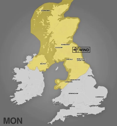
Storm Floris has been named by the Met Office and is set to bring unseasonably strong winds to the UK on Monday.
Gusts of up to 85mph are possible along exposed coasts and hills inScotland, while other other parts of the UK could reach 50-60 mph inland.
A yellow Weather warning for wind is in place in Scotland, Northern Ireland, north Wales and the north of England from 6am on Monday to 6am on Tuesday.
In other parts of England and Wales it will still feel particularly windy, however, less severe.
The Met Office stated there was a few a few uncertainty in the ‘depth and track of Floris’, but it predicts ‘winds will first ease in the west during later Monday however remaining very strong overnight until early Tuesday in the east’.
Heavy Rain is also forecast, with transport disruption expected in a few places.
Today will be a dry day for most, with sunny spells, the Met Office predicts.
Showers are set to develop across central and eastern England, a few turning locally heavy in the afternoon ‘with the odd rumble of thunder possible’.


Saturday should be dry with plenty of sunshine and small amounts of cloud and light winds.
Sunday looks to be a bit breezier, with rain clearing to sunnier skies later in the day, before Storm Floris arrives on Monday.
Temperatures will hover around average for this time of year over the next few days, sitting at somewhere between 20C-23C.
Storm Floris is the sixth named storm of the 2024/2025 Storm Naming season.
Storm Éowyn – which happened in late January – was the last named storm to affect the UK, leaving two dead and more than 1 million without power.
Although named Storms are more frequent in late autumn and winter, it is not uncommon for them to occur in summer, the Met Office stated.